


Le bleymard - le pont de monvert

simonm0204
User

Length
21 km

Max alt
1699 m

Uphill gradient
667 m
Km-Effort
30 km

Min alt
875 m

Downhill gradient
859 m
Boucle
No
Creation date :
2023-04-23 06:42:03.0
Updated on :
2023-04-23 15:10:51.578
8h19
Difficulty : Very easy

FREE GPS app for hiking
 SityTrail
IGN / Geographical institutes
SityTrail Plus
The world is yours!
About
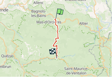
Trail Walking of 21 km to be discovered at Occitania, Lozère, Mont Lozère et Goulet. This trail is proposed by simonm0204.
Photos

Positioning
Country:
France
Region :
Occitania
Department/Province :
Lozère
Municipality :
Mont Lozère et Goulet
Location:
Le Bleymard
Start:(Dec)
Start:(UTM)
558802 ; 4926575 (31T) N.
Comments